Chiang Dao Trip Planner: Background Guide and Main Attractions
By David Foster · Author · · Updated
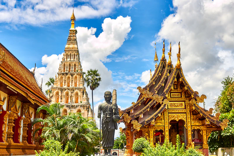
Planning a Trip to Chiang Dao
Travelers seeking to understand the region before visiting will find that Chiang Dao is a town situated in a valley among green mountains in Chiang Mai Province, Northern Thailand, north of the city of Chiang Mai. Understanding the geographical context of a destination is a foundational step in any travel planning process. By recognizing that the area is nestled within a valley surrounded by a mountainous landscape, visitors can better anticipate the type of environment they will encounter upon arrival. Preparing for a journey to a town in Northern Thailand involves considering the terrain and how it shapes the local geography. The position of the town north of the provincial capital provides a distinct setting for those looking to explore beyond the immediate city limits. Planners can use this geographical baseline to structure their itineraries, ensuring they allocate suitable time for navigating mountainous terrain. Knowing the physical layout of the destination allows travelers to organize their expectations regarding the natural surroundings.
Geography and Routing
For logistical planning, it is useful to know that the town of Chiang Dao is located on the slopes of Doi Chiang Dao, above the Mae Nam Ping Gorge. The placement on the slopes dictates the immediate topography of the town itself. Furthermore, the position above the gorge highlights the varied elevations present in the area, which is a common characteristic of mountainous regions. Travelers mapping out their route will note that Highway 107 travels 72 kilometres north from Chiang Mai to Chiang Dao. Recognizing the specific highway and the exact distance is critical for travel preparations. When organizing transportation, knowing that the journey involves a 72-kilometre route heading north provides a clear framework for estimating transit durations, depending on the chosen method of travel. Visitors can check official sources for updates on road conditions or routing changes before departing. Thorough preparation involving distance and route identification ensures that transit logistics are properly managed.
Overview of Major Attractions
A comprehensive itinerary relies on identifying the primary points of interest in the destination. The main tourist attractions in the area are Chiang Dao Cave, Doi Chiang Dao, and Pha Daeng National Park. By isolating these key locations, travelers can begin to categorize their trip into subterranean exploration, high-altitude environments, and broad national park visits. Structuring a visit around these core attractions allows for a balanced experience of the region's natural offerings. Visitors can prioritize their time based on which of these environments aligns best with their interests. A well-rounded plan might allocate distinct days or portions of a day to each of these major sites. Coordinating visits to caves, mountains, and parks requires evaluating the physical demands of each attraction and planning accordingly to ensure a structured approach to the trip.
Exploring Subterranean Environments
Those interested in geology and underground formations will often focus on the local cave systems. Chiang Dao Cave, located within the Chiang Dao Wildlife Sanctuary, has 12 kilometres of stalactite caves, with five caverns open to the public. The extent of the cave system highlights the scale of the geological formations present within the sanctuary boundaries. Knowing that only five caverns are accessible to the public is an essential piece of information for managing expectations. Travelers will understand that while the network is expansive, their actual exploration is limited to specific, permitted sections. Visitors can prepare for walking through enclosed spaces and viewing the natural stalactite formations. Assessing the scale of the accessible areas helps in determining exactly how much time to dedicate to the cave portion of the itinerary. It is advisable to review any guidelines regarding cave entry to ensure the environment remains undisturbed.
Mountain Peaks and Wildlife Sanctuaries
The high-altitude features of the region define its skyline and appeal to those interested in significant elevations. Doi Luang Chiang Dao is a 2,225-metre conical limestone mountain inside the Chiang Dao Wildlife Sanctuary, ranking as Thailand's third-highest peak. Recognizing the mountain's specific elevation and its status as the third-highest peak in the country provides context for the immense scale of the landscape. The conical shape and limestone composition are notable geographical features that distinguish the mountain within the broader sanctuary. Travelers interested in high peaks can factor this prominence into their viewing or exploration plans. The location entirely within a wildlife sanctuary indicates an environment dedicated to conservation and natural preservation. Visitors planning to view or approach the mountain must consider the preparation typically required for protected wildlife areas. The height of the peak dominates the visual landscape for anyone in the vicinity.
National Parks and Flora
In addition to specific peaks and caves, the broader protected areas offer extensive natural environments for visitors to consider. Pha Daeng National Park covers more than 1,000 square kilometres of craggy mountains and bamboo forests starting right next to the town. The massive scale of the park indicates that thorough exploration would require significant time and planning. The presence of craggy mountains and bamboo forests outlines the specific types of flora and terrain travelers can expect to encounter. The fact that this expansive park begins right next to the town means that visitors do not have to travel far from the settlement to enter the protected area. Planners can use this proximity to seamlessly transition from town environments to expansive nature reserves without lengthy transit times. Understanding the massive footprint of the park helps visitors realize that they will likely only see a fraction of it during a standard trip.
Isolated Temples and Scenery
Beyond the primary natural parks and caves, the region offers distinct cultural sites set within the landscape. Wat Pa Bunnak is an isolated temple situated to the northeast of Chiang Dao, surrounded by rice fields and scenery. The isolated nature of the temple suggests a quieter environment away from the main town center. Its location to the northeast provides a specific directional cue for route planning and geographic orientation. The surrounding rice fields and scenery offer a different visual experience compared to the dense bamboo forests or craggy mountains found elsewhere in the area. Travelers looking for varied landscapes can include this temple in their itinerary to balance the rugged mountain terrain with pastoral agricultural settings. Visiting an isolated site surrounded by scenery requires considering the logistics of reaching a less central location, reinforcing the importance of thorough and careful trip planning.
Sources
Written by David Foster.